In setting up or in revising sales territories, there are four steps: (1) selecting a basic geographical control unit, (2) determining sales potentials in control units, (3) combining control units into tentative territories, and (4) adjusting for coverage difficulty and redistricting tentative territories.
1. Selecting a Basic Geographical Control Unit
The starting point in territorial planning is the selection of a basic geographical control unit. The most commonly used control units are counties, Zip code numbers, cities, standard metropolitan statistical areas, trading areas, districts, and states. Sales territories are put together as consolidations of basic geographical control units.
There are two reasons for selecting a small control unit. One reason is to realize an important benefit of using territories, the precise geographical identification of sales potential. If the control unit is too large, areas with low sales potentials are hidden by inclusion with areas having high sales potentials, and areas with high sales potentials are obscured by inclusion with those having low sales potentials. The second reason is that these units remain relatively stable and unchanging, making it possible to redraw territorial boundaries easily by redistributing control units among territories. If, for example, a company wants to add to Jones’s territory and reduce Smith’s adjoining territory, it is easier to transfer district-sized rather than state-sized control units.
Counties. In the United States, the county is the most widely used geographical control unit. The county is small enough to prevent the obscuring of areas with high and low sales potentials, and statistical information on the more than 3,000 counties in the United States is readily available. This makes it inexpensive to develop market and sales potentials on a county-by-county basis. Furthermore, the county typically is the smallest unit for which governmental sources report statistical data. The county is a smaller market division than the typical sales territory, so a company using counties as control units can build up or revise sales territories without collecting new data on potentials.
Zip code areas. A basic geographical unit increasingly used by U.S. companies is the Zip code area. There are more than 33,000 Zip code areas in the United States, so the typical Zip code area is smaller than the typical county. Using Zip code areas as the basic geographical units has advantages. The Zip code areas generally reflect economic characteristics of the areas—in marked contrast to counties, cities, and states, which represent political subdivisions. The Zip code system permits a precise definition of markets according to economic and demographic characteristics. Each Zip code area is a convenient unit for which to collect data on market and sales potentials.
Cities. When a company’s sales potential is located entirely, or almost entirely, in urbanized areas, the city is used as the control unit, although, in some cases, both the city and the surrounding county (or counties outside the city) are used as “twin” control units. The city rarely is fully satisfactory as a control unit, inasmuch as most grow beyond their political boundaries. For many products, suburbs adjacent to cities possess sales potentials at least as great as those in the cities themselves, and, in addition, they can often be covered by the same sales personnel at little additional cost.
Metropolitan statistical areas. Companies whose markets have expanded beyond city limits and into suburbs and satellite cities find the Metropolitan Statistical Area (MSA) a good choice for basic geographical control unit. An MSA is a geographic area with a large population nucleus together with adjacent communities that have a high degree of economic and social integration with that nucleus. In addition to the county containing the central city, the MSA may include additional counties with close economic and social ties to the central county.
For some companies, MSAs are too large to serve as basic geographical control units. These companies deal directly with large numbers of customers in urban areas, and commonly they assign more sales personnel to the same MSA. In such cases, companies use either minor political divisions of cities—precincts and wards, or clusters of contiguous census tracts—or city blocks as control units. The main problem in using these control units is the difficulty encountered in obtaining market statistics, although statistics are obtainable by census tract.
Trading areas. A logical choice for a geographical control unit is the trading area, since it is based upon the natural flow of trade. Formally defined, a.trading area consists of the geographical region surrounding a city that serves as the dominant retail or wholesale center or both for the region. The trading-area concept recognizes that consumers, retailers, and wholesalers pay scant attention to political boundaries in deciding where to buy. Consumers, for example, regard convenience and the merchandise selection available as key factors in deciding where to shop. People living in suburban Connecticut or New Jersey, for instance, may reason that the best selection of the desired type of product is in New York City, and conclude that New York is reasonably convenient to get to, and subsequently shop and buy the item there. Shopping across political boundaries is common, especially where population concentrations are close to state lines and where suburban areas have spread into counties surrounding cities.
Many consumer products, including most specialty and shopping goods, are available almost entirely in large regional shopping malls. So residents of small towns and rural areas must travel to these malls (or, of course, order by mail or phone). Increasingly, too, residents of the older areas of cities, when they are in the market for these items, go to outlying shopping malls.
It is difficult to define the limits of trading areas, as they vary from product to product. But because trading areas are based on natural trade flows, they are considered in planning sales territories even though they are not selected as geographical control units. The main problems in using trading areas as control units are defining them and estimating sales potentials.
Depending upon the product, both retail and wholesale trading areas vary in size and shape and change over time. Rural consumers buy work clothes and routine supplies in the nearest small towns, but they go to regional
shopping malls or larger cities to shop for dress clothing, and even farther to buy expensive furniture or jewelry. Each such location is the focal point for a trading area, at least for products customarily purchased there. Trading areas for products purchased frequently and routinely are much smaller in size, and consequently more numerous, than are those for luxury products.
Precise delineation of trading areas requires primary research into, and quantification of, customers’ buying habits and preferences. Considerable expense is involved in dividing market and sales potentials for counties or other political subdivisions among two or more trading areas. Consequently, most companies using trading areas as control units adjust trading-area boundaries to county lines.
Other features of trading areas limit their usefulness as control units. Every trading area has at least one city as a focal point, but it may be far from the area’s geographical center, complicating the planning of routes and call schedules for sales personnel. Many trading areas contain both areas of high population density and of thinly settled forest, desert, or farmland, so care must be taken to prevent obscuring of areas with high and low sales potentials. Some trading areas are circumscribed partially by impassable geographical barriers and partially by the relative trading importance of neighboring areas, both of which change with highway construction projects and the development of new shopping malls. Sizes and shapes of trading areas even fluctuates seasonally; climatic conditions, such as snowfall in intervening mountainous areas, cause some cities to have separate summer and winter trading areas.
Some companies, however, identify trading areas for their own products. The most difficult problem is to allocate sales potential data among trading areas. This causes some executives who recognize the basic logic of the trading-area concept nevertheless to use other control units, such as counties or standard metropolitan statistical areas. They feel that the greater realism obtainable through identifying and delineating trading areas for their company’s products is not worth facing the problem of allocating sales potential data.
States. States, as basic geographical control units, provide a rough basis for subdividing the national market. There are two situations in which the fixing of territorial boundary lines along the borders of states is justifiable. One is the company with a small sales force covering the market extensively rather than intensively; there are only a few customers and prospects, but they are all across the nation. The other situation is the company first seeking national distribution, which assigns its sales personnel to territories consisting of one or more states as a temporary expedient. As soon as feasible, a change is made to a smaller control unit. The main difficulty in using states as basic control units is that they are political rather than economic subdivisions. A Delhi-Rajasthan boundary, for instance, ignores the fact that numerous consumers and intermediaries in the border areas of Rajasthan do their buying in Delhi, and a Gujarat-Maharashtra boundary ignores the fact that many Gujarat consumers and other buyers trade in Mumbai, Maharashtra.
2. Determining Sales Potential Present in Each Control Unit
The next step is to determine the sales potential present in each central unit. The territorial planner needs some way to measure sales potentials, which, you will recall, represent the maximum possible sales opportunities open to a specific company selling a good or service during a stated future period to particular market segments. For the present purpose, substitute “a particular control unit” for “a particular market segment”, in other words, each control unit is a particular geographical market segment. Geographical market segments, like all market segments, are made up of present and prospective customers, so the territorial planner must identify the buyers of the product as precisely as possible. A vague identification such as, “Our product is bought by women,” is not sufficient. But if it can be determined that “Our product is bought almost entirely by middle-aged, lower-income women living in cities,” a more precise description of the buyers comprising the market is obtained. Formal market identification studies may be necessary.
Sometimes, sales personnel supply information, but it is not necessarily usable. For example, a sales force calling only on wholesalers has little contact with retailers or consumers. Even when sales personnel sell to final buyers, as in marketing many industrial goods, they may neglect certain classes of prospects and be able to provide only partial identification of possible buyers. When there is no direct contact with final buyers, formal marketing research studies obtain precise identification of all classes of final buyers. Whether or not this process should be carried as far as identification of each possible buyer will depend upon the product being marketed. In consumer goods, it is unnecessary and too expensive to go to this extreme. In industrial goods, where often there are only a few possible buyers, exact identification is desirable and feasible.
Having identified potential buyers, the planner next determines the sales potential in each control unit. The planner ascertains how many potential buyers in each class there are in each control unit and the unit’s total market potential. Then the planner estimates the portion of the unit’s market potential that the company has an opportunity to obtain (that is, the sales potential).
Market potentials are generally converted into sales potentials by analyzing historical market shares within each control unit, adjusting for changes in company and competitors’ selling strategies and practices, and arriving at estimates. Having made these estimates, the territorial planner ascertains those control units with sufficient sales potential to justify sales coverage. For the manufacturer with mass distribution, this is not a problem. Mass marketers provide sales coverage in every control unit, regardless of how little sales potential it represents, because maximum sales exposure is crucial to marketing success. Many manufacturers, however, provide sales coverage only in those control units containing sufficient sales potential to assure profitable operations, and for most manufacturers, there are some control units where selling costs are excessive. This is true of numerous industrial-goods producers, such as those selling machine tools and mining equipment. (Studies of industrial-goods markets show that over 90 percent of U.S. manufacturing is done in approximately 650 of the 3,000 counties.) It is also true of most producers of consumer shopping and specialty goods; the bulk of the market lies in a small number of market areas.
3. Combining Control Units into Tentative Territories
The planner next combines units into tentative sales territories. This is only a tentative arrangement because, as explained later, subsequent adjustments must be made for relative coverage difficulty. At this stage, the planner assumes that no significant differences in the physical or other characteristics of individual control units exists. The purpose is to obtain a “first approximation” of sales territories, by combining contiguous control units into tentative territories, each containing approximately the same sales potential.
At this point, however, the planner decides the number of territories, and this, assuming that all sales personnel are of, average ability, is identical to deciding sales force size. Basically, the planner estimates the percentage of total sales potential that the average salesperson should realize. Analysis of past sales experience helps in making this estimate, which, once made, is used to determine the number of territories. In effect, the planner estimates the sales productivity per sales personnel unit and divides it into the total estimated sales potential, thus arriving at the number of sales personnel units—and territories—required. Assume that management estimates that an average salesperson should realize $2,500,000 of a total sales potential of $25 million—ten territories and ten units ($25,000,000/$2,500,000) of sales personnel are required. When these estimates and this calculation have been made, contiguous control units are combined into tentative territories of roughly equal sales potential. To simplify this step, sales potentials for control units are expressed as percentages of total sales potential. In the example, then, control units are grouped into ten tentative territories, each containing, about 10 percent of the sales potential. Throughout this grouping process, the planner combines only control units contiguous to each other; individual control units are not split into different territories, even if this results in tentative territories with different total sales potentials.
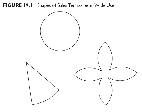
Territory shape. The planner now considers territory shape. The shape of a territory affects both selling expenses and ease of sales coverage. In addition, if the shape of a territory permits the salesperson to minimize time on the road, it contributes to sales force morale. Three shapes are in wide use: the wedge, the circle, and the clover leaf (see Figure 19.1).
The wedge is appropriate for territories containing both urban and nonurban areas. It radiates out from densely populated urban center. Wedges, of course, can be in many sizes (up to just under 360 degrees). Travel time among adjoining wedges can be equalized by balancing urban and nonurban calls.
The circle is appropriate when accounts and prospects are evenly distributed throughout the area. The salesperson assigned to the circular-shaped territory is based at some point near the center, making for greater uniformity in frequency of calls on customers and prospects. This also makes the salesperson nearer to more of the customers than is possible with a wedge-shaped territory. The clover leaf is desirable when accounts are located randomly through a territory. Careful planning of call schedules results in each cloverleaf being a week’s work, making it possible for the salesperson to be home weekends. Home base for the salesperson assigned to the territory is near the center. Clover-leaf territories are more common among industrial marketers than they are among consumer marketers and among companies cultivating the market extensively rather than intensively.
4. Adjusting for Differences in Coverage Difficulty and Redistricting Tentative Territories
The final step is to redistrict the tentative territories through adjusting for coverage difficulty. The tentative territories each contain approximately the same sales potential, but, almost certainly, territories with nearly equal sales potentials require different selling efforts and, in turn, selling expense totals. Now it is time to remove the unrealistic assumption that no differences in the characteristics of geographical Control units exist. Significant differences in physical and other characteristics make providing sales coverage more difficult for some control units than for others. Certain large cities, for instance, have greater sales potentials for most products than some states, but the time required to contact customers and prospects in cities is much less, and the same is true of selling expenses. As the planner adjusts for differences in coverage difficulty, control units are taken away from some tentative territories and added to others. The final territorial arrangement almost certainly is one in which different territories contain different sales potentials.
Differences in coverage difficulty represent differences in workloads. The planner ascertains how large the maximum work load—the largest work load for any salesperson—should be. All workloads need not be the same size, since sales personnel vary in ability as well as in drive, and some can safely be assigned larger workloads. However, since there is an upper limit to the “desirable work load,” and this also limits a territory’s maximum geographical extent. When final adjustments for coverage difficulty are made, sales territories have varying amounts of sales potential and different-sized workloads, but none exceeds the maximum desirable work load. The work load method was discussed in Chapter 5 as one approach to determining sales force size. Here, the same concept, with minor modifications is used for redistricting.
Redistricting to adjust for coverage difficulty (that is, differences in workloads) is a seven-step procedure:
- Determine number, location, and size of customers and prospects in each tentative territory. Customers are identified and located through sales records; prospects through trade directories, subscription lists to trade publications, classified directories, and credit-reporting agencies. Size is measured in terms of sales potential.
- Estimate time required for each sales call. This varies from account to account and from prospect to prospect, so customers and prospects are classified into groups, estimating an average time per call for each group. Time and duty analyses of sales personnel are used to check these estimates.
- Determine length of time between calls, that is the amount of time required to travel from one customer to the next. This varies among regions, depending on the density of customers and prospects and the condition of roads and transportation facilities. Particular attention is paid to physical characteristics. Large rivers, lakes, mountains, and other barriers to travel make natural and necessary territorial boundaries. The number of places where a large mountain range can be crossed by automobile are limited and often considerable time is consumed in the crossing. The same is true of large rivers, lakes, bays, and so forth. Transportation facilities are as important as physical characteristics. If travel is by automobile, territories are planned so that driving is mainly on primary, all-weather roads, with minimum cross-tracking. If public transportation facilities such as commercial airlines are used, territories are planned with an eye on locations of air terminals. The planner interrelates and balances differences in sales potential, physical geographical characteristics, and transportation facilities and routes. After sketching in on a map the tentative territorial division according to roughly equal sales potentials, the planner makes adjustments after superimposing maps showing topographic and transportation features.
- Decide call frequencies. Within certain control units, some or all customer and prospect classes require call frequencies that differ from those in other control units. Differences in the strength of competition require variations in call frequency rates. Similarly, call frequency rates are influenced by the market acceptance of the product line within control units. Cost studies on minimum profitable order sizes also provide input to the decision on call frequencies.
- Calculate the number of calls possible within a given period. This is a matter of simple arithmetic. To determine the number of calls per day in a certain control unit, the average amount of time required for each call is added to the average time between calls and divided into the number of working hours in the day. Adjustments are made when call lengths vary for different classes of customers and prospects.
- Adjust the number of calls possible during a given period by the desired call frequencies for the different classes of customers and prospects. This results in an estimate for the total work load represented by the control units in each tentative territory. Further adjustments are made to assure that the work load in any territory is not larger than the allowable maximum and that selling expenses are within budget limits. The planner shifts control units among different tentative territories, adding units to some by taking them away from adjacent territories. Each shift brings the territorial arrangement closer to the optimum—that is, closer to one in which incremental sales per dollar of selling expenditures are equated among all territories.
- Finally, check out the adjusted territories with sales personnel who work or who have worked in each area, and make further adjustments as required. Personnel familiar with customer service requirements, competitive conditions, and the topography, roads, and travel conditions may point out weaknesses not obvious to the planner. These cause further shifting of control units from one territory to another, each shift bringing the final territorial arrangement a little closer to the optimum.
5. Deciding Assignment of Sales Personnel to Territories
When the arrangement is the best obtainable, it is time to assign sales personnel to territories. Up to this point in territorial planning, an implicit assumption has been that all sales personnel are “average,” that is, that all are interchangeable, each capable of producing similar results at similar costs regardless of territorial assignments. Clearly, this is an unrealistic assumption, adopted only for territorial planning purposes, and one that is discarded when sales personnel are assigned to territories. Few sales personnel are average—they vary in ability, initiative, and effectiveness as well as in physical condition and energy. What constitutes a reasonable and desirable work load for one individual may not be appropriate for another person. Furthermore, salesperson’s effectiveness varies with the territory assigned. One person is outstanding in one territory and a failure in a second, even hough territorial sales potentials and coverage difficulty factors are almost identical. Performance, moreover, is conditioned by customer characteristics, customs and traditions, ethnic influences, and the like. Dyadic interactions, with customers and prospects, in other words, vary in their outcomes from one territory to another depending on many factors, most of them outside the salesperson’s control.
In assigning sales personnel to territories, management seeks the most profitable alignment of selling efforts with sales opportunities. The territories, containing varying sales potentials, represent different amounts of sales opportunity. The sales personnel, differing in ability and potential effectiveness, represent the range of available selling talent. The general guide for assigning sales personnel to territories is not universally applicable because the discretion that management has in making these decisions differs from company to company. At one extreme, some companies display great reluctance to transfer sales personnel to different territories, management fearing not only sales force resistance but the consequences of breaking established salesperson-customer relationships. These companies adhere to a “no transfer” or “infrequent transfer” policy and build restrictions on shifting sales personnel into territorial designs. The planner expands or contracts territorial boundaries, adding to or subtracting from individual territorial sales potentials, until territories contain, sales potentials appropriate to the abilities of assigned sales personnel. These companies, in effect, design sales territories around, and to fit the abilities of sales personnel.
At the opposite extreme, management in a few companies is free to assign any salesperson to any territory, designing territories (according to procedures like those discussed earlier) and closely aligning salespeople’s ability levels with territorial sales opportunity levels. Management shifts sales personnel to predesigned territories where their relative profit contributions are maximized.
The situation in most companies is somewhere between the two extremes. For various reasons, some totally outside management’s control, certain sales personnel are not transferable, but others are freely moved from one territory to another. This means that management designs some sales territories to fit the ability levels of nontransferable sales personnel while reassigning other sales personnel with ability levels appropriate to sales territories redesigned according to the suggested procedures.
Illustration of Assigning Sales Personnel to Territories. Now let us work through several situations involving assignment of sales personnel to territories with our purpose being to demonstrate that, where practical, effective sales management assigns each salesperson to the territory where his or her relative profit contribution is maximized.
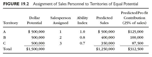
First, consider the situation in which territories have equal sales potential and coverage difficulty, but the sales personnel differ in ability.
Figure 19.2 depicts this situation. Predicted sales are obtained by multiplying each territory’s dollar potential by the ability index of the salesperson assigned. Predicted profit contributions are assumed to amount to 25 percent of predicted sales. The total profit contribution is $312,500, the maximum attainable here regardless of how the sales personnel are assigned.
Now suppose that these territories are redesigned so that their sales potentials vary in direct proportion with the ability of the sales personnel assigned, with the same total dollar potential as before ($1.5 million). The results of this assignment pattern are shown in Figure 19.3. Redesigning territories so that sales potentials are directly proportional to abilities of assigned sales personnel increases the predicted profit contributipn by $7,000 (from $312,500 to $319,500).

But what is the predicted profit contribution if total sales potential is divided some other way? After all, the number of possible ways of dividing it is very large. Consider Figure 19.4, which shows a different division of the $1.5 million sales potential; sales personnel, however, are still assigned territories in rank order of their respective abilities.
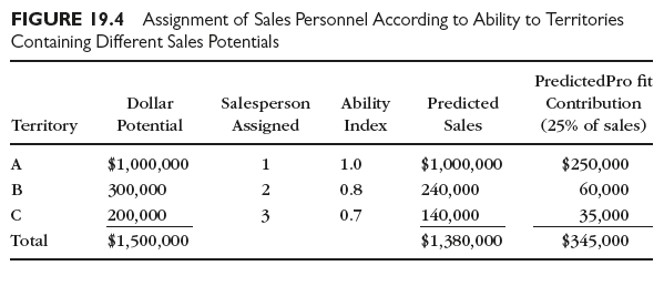
Again there is an increase in the predicted profit contribution, this one even more impressive than in the preceding example. However, it is unlikely that this is a feasible territorial division and salespersons assignment plan. The coverage difficulty and associated work load now involved in covering territory A would likely exceed salesperson l’s capacity to perform; thus, l’s ability index should be lowered. Similarly, territories B and C now have such greatly reduced sales potentials (which means that their coverage difficulty is less than before) that probably neither would represent sufficient workloads for salesperson 2 or 3.
There are upper and lower limits to the amount of sales potential to incorporate in any one territory. These limits are set by coverage difficulty and the size of the work load that it is reasonable to expect any salesperson, regardless of ability, to assume. Then, too, selling expenditures do not fluctuate directly with predicted sales volumes throughout all sales volume ranges. They may rise more or less in proportion to sales volume increases, but after a certain point is reached, the rate of rise accelerates greatly (that is, as the difficulty of making sales becomes increasingly greater), and they may decline proportionately to sales volume decreases until a minimum level is reached (where potential sales are no longer large enough to support needed selling expenditures). Workload restrictions, in other words, confine the uniformity of variation of selling expenditures within fairly narrow limits.
The optimum territorial arrangement is reached when the incremental sales produced per dollar of selling expenditures are equated among all territories. After a sales territory reaches a certain size in terms of sales potential, adding successive increments of sales potential is feasible only up to the point at which the last dollar of selling expenditures just brings in sufficient sales to provide a dollar of profit contribution. A company seeking the optimum territorial arrangement generally concludes that it is wise to cut off additional selling expenditures before reaching this “point of feasibility.” This is because the best condition requires the equating among all territories of the incremental sales produced by the last dollar of selling expenditures in each.
Thus far, an implicit assumption has been that ability indexes do not change with assignment of sales personnel. However, sales personnel have different degrees of effectiveness in different territories, because environmental forces condition selling performance. It is not realistic, in other words, to assume that ability indexes for individual sales personnel are fixed regardless of the territorial assignment.
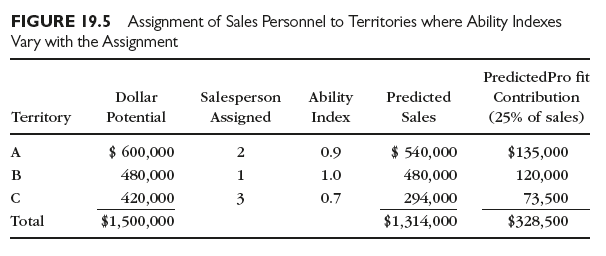
Consider, then, a situation where sales personnel maintain their rank order according to ability indexes as they are switched among territories but where the indexes change. With the assignment pattern 1A, 2B, 3C, the respective ability indexes might be 1.0, 0.8, and 0.7 (as in Figure 19.3, for example), but with the assignment IB, 2A, 3C, the respective ability indexes could be 1.0, 0.9, and 0.7—salesperson 1 in this situation performs better than salesperson 2 regardless of the assignment. Using the basic data in Figure 19.3, the results of the 1B-2A-3C assignment are shown in Figure 19.5. This assignment pattern results in a higher total profit contribution than that secured by assigning sales personnel to territories strictly in accord with their abilities (that is, $328,500 versus $319,500). Thus in some territorial designs, the best salesperson should not necessarily be assigned to the territory with the highest sales potential, and in some, a salesperson should not necessarily be assigned to the one territory where his or her profit contribution is higher than that of any other salesperson who might be assigned to the same territory. Each salesperson should be assigned to the territory where his or her relative contribution to profit is the highest.
In Figure 19.5 salesperson 1 could make a higher dollar profit contribution than salesperson 2 in territory A, but 1 contributes more, relative to 2, when assigned to territory B. Similarly, salesperson 2’s inferiority relative to salesperson 1 is less when 2 has territory A, not territory B.
Ability indexes change with different assignment patterns; consequently, management estimates ability indexes for each possible assignment pattern. The large number of possible assignment patterns makes complex the task of achieving an ideal assignment. When twelve salespeople are to be assigned to twelve territories, for example, there are 12! (that is 479,001,600) possible patterns. It would be possible, although not practical, to write down all 479,001,600 assignment patterns and select the one providing the maximum profit contribution; fortunately, however, the assignment linear programming technique and the computer afford a rapid and less laborious way to find the solution. But even this technique requires estimates for the probable net profit contribution for each salesperson for each possible assignment pattern, and this requires not only knowledge of the nature and peculiarities of each territory, but insight on how each salesperson might perform in each territorial environment.
Source: Richard R. Still, Edward W. Cundliff, Normal A. P Govoni, Sandeep Puri (2017), Sales and Distribution Management: Decisions, Strategies, and Cases, Pearson; Sixth edition.
24 May 2021
25 May 2021
24 May 2021
24 May 2021
25 May 2021
25 May 2021